|
PART 1 T O P I C |
|
|
|
|
|
|
|
|
|
|
|
|
|
|
|
|
|
|
|
|
|
|
|
CLICK BUTTON |
|
|
|
|
|
|
|
|
|
Israel |
|
|
|
|
|
|
|
ISRAEL - PALESTINIAN |
|
|
|
|
|
|

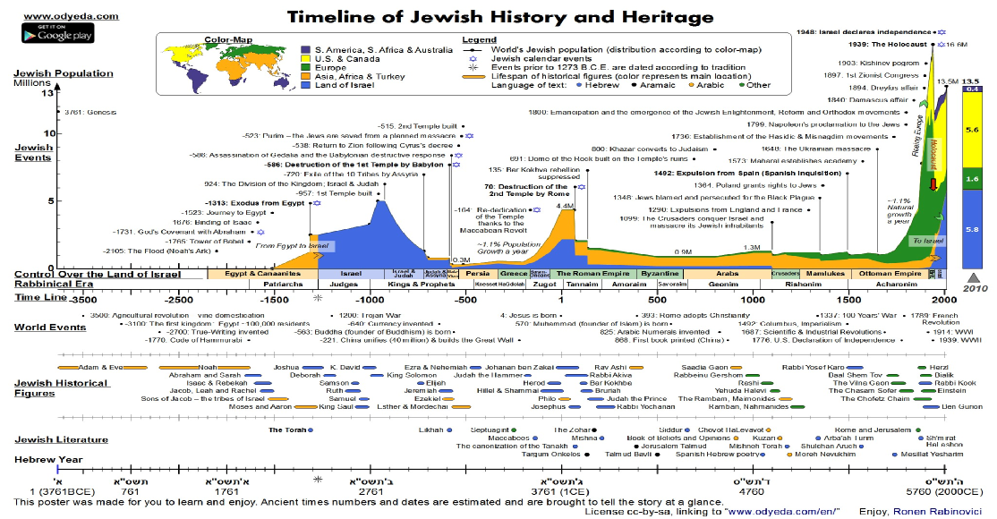
JewishWikipedia.info
THE
INCREDIBLE
STORY OF THE JEWISH PEOPLE
ISRAEL
is a country of
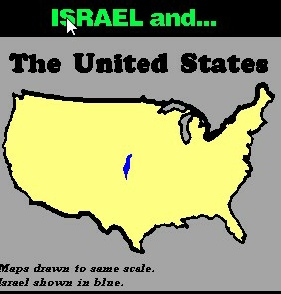
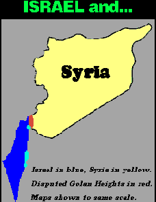
8,359 sq miles.
THE WEST BANK is 2,262 sq miles, THE GOLAN HEIGHTS
is 444 sq miles
and
GAZA
is 100 sq miles.
THE USA
is 3,794,083
sq. miles
SYRIA
is 71,498
sq miless
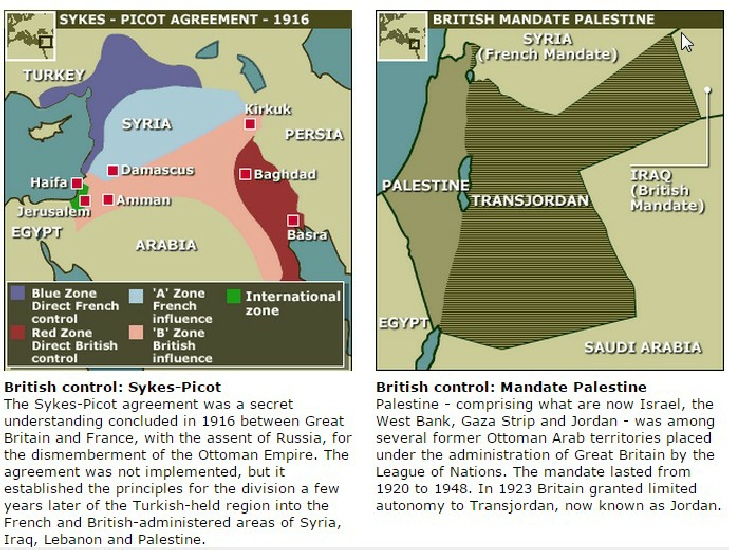
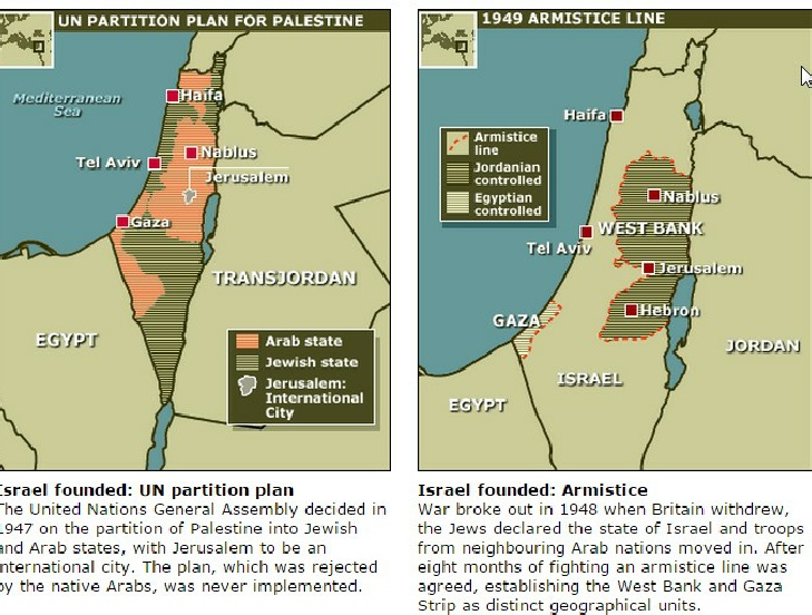
Until the end of WW1 most of the Middle East was part of the Ottoman Empire. Palestine was then placed under Great Britain by the League of Nations. Their mandate lasted from 1920-1948. Part of the area became Transjordan (now Jordan) with the remainder remaining under British control. After WW2 the UN split the area into two parts, a Jewish state (becoming Israel) and an Arab state. Accepted by Israel it was not accepted by the Arabs who invaded Israel the day after the British left to eliminate it.. Since then Israel has faced wars and terrorist attacks to eliminate it. For security it has created the Israel Defence Force with compulsory military service..
The population of Israel has grown with worldwide immigration which includes refugees from concentration camps and Jews expelled by Arab countries. The refusal to resettle the Arab refugees by the Arab League left them in UNRWA camps.. Israel saw this movement as a population transfer as happened when India was split into India and Pakistan. The Arab League decided that leaving refugees in camps would be a future political counter against Israel.
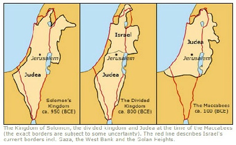
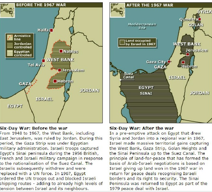
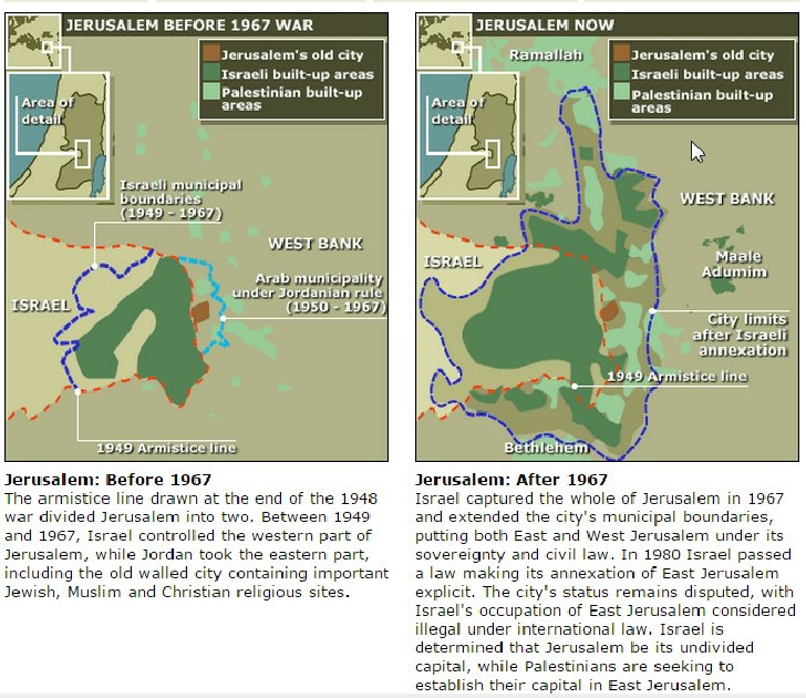
Maps and events of subsequent wars aimed at destroying Israel are shown below.
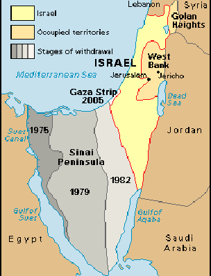
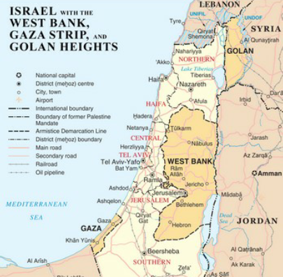
ISRAEL’S BORDERS
Rep. Ron DeSantis (R-FL)
NYS of mind 2017 (5.14)
Rep. Ron DeSantis (R-FL) is one informed and proud American.
He spoke in the US House of Representatives on Jan 11, 2017.
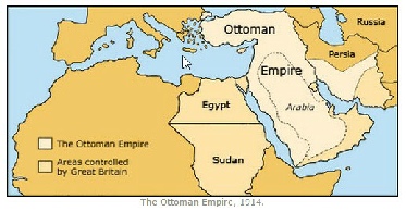
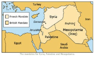
The Ottoman Empire, 1914
The French and British
Mandates for Syria, Palestine
and Mesopotamia after WW1
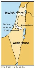
The British
Peel Commission Report (1937)
Boundaries for the
Division of Palestine
into Arab and Jewish States
The Red Line shows
Israel’s borders,
Gaza and the Golan Heights
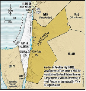
In 1923 London recognized the existence in Transjordan of a government under Abdullah as emir. In 1928 it was, recognised as an ’emirate’, or principality. Its formal independence from the UK was in 1946.
His title upgraded to ‘King’ and name
to the Hashemite Kingdom of Jordan.
, Israel Borders - 1923 - 1993")

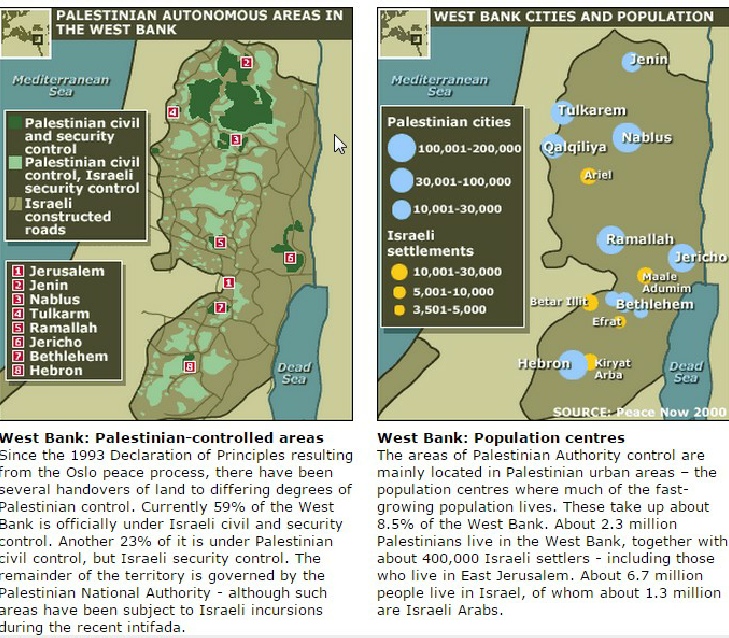
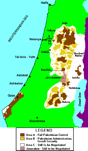
WEST BANK (1)
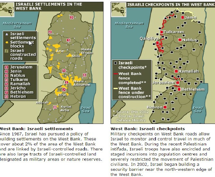
see also Israel’s Settlements
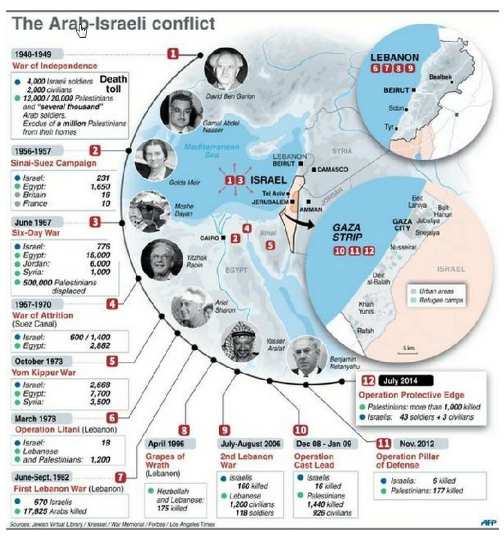
YOM KIPPUR (1973) WAR
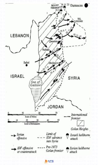
1973 October War (Yom Kippur War) -
Syrian Front
Mid East Maps
In October 1973, Egypt and Syria launched another war against Israel, after the Israeli government headed by Golda Meir rebuffed Egyptian President Anwar Sadat's offers to negotiate a settlement. Less than 200 Israeli tanks were left guarding the Golan heights against far superior numbers. Syrians made serious and at first unopposed inroads in the Golan before being repulsed by Israeli armor and the Israeli air force. Like the Egyptians, the Syrians enjoyed the advantage of surprise, and the fact that Israel did not initially have solutions for the hand-held Sager anti-tank missiles and the radar-guided SAM anti-aircraft missiles.
Map adapted from Benny Morris, Righteous Victims, 2000.
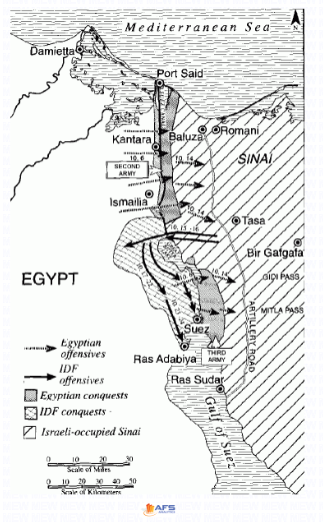
1973 October War (Yom Kippur War) -
Syrian Front
Mid East Maps (abridged text)
The Egyptians crossed the Suez Canal on October 6, Yom Kippur, the holiest day in the Jewish religious calendar.
The Israelis were caught by surprise Egyptians poured huge numbers of troops across the canal set up a beachhead. The Israel Bar Lev line, was to hold off the Egyptians as long as possible. The tiny number of soldiers were wiped out . The air-force was initially neutralized because of Egyptian SAM missiles, until Israel could destroy the radar stations controlling them. Initial Israeli attempts to oppose the Egyptians without artillery support were fruitless. Israeli forces rallied and developed a bridgehead on the Egyptian side of the Suez canal,
Map adapted from Benny Morris, Righteous Victims, 2000.
Click here
for an explanation of
West Bank Areas A, B and C
WEST BANK - AREAS A, B AND C
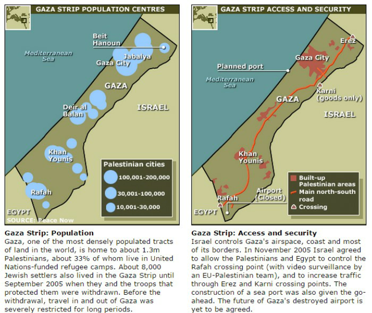
GAZA STRIP
sIX
TERROR WATCH
https://www.breakingisraelnews.com/category/terror-watch/
May 12 2019
THE MAP HISTORY OF MODERN ISRAEL